Recently we have started the plate tectonics unit of Earth Science. Alfred Wegener was the first to propose continental drift. He cited coastlines and fossils as clues that all the continents once fit together like a puzzle in a supercontinent called Pangea. The coastlines of South America and Africa were two pieces in the puzzle. He found fossils of the freshwater Mesosaurus on south america and Africa, as well as fossils of the Glossopteris fern. He, however proposed that the continents movement was due to them floating on the ocean.
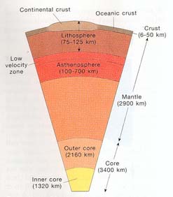
The Theory of Plate Tectonics states that the lithosphere is broken into pieces, called plates, that “float” on the asthenosphere and “move” due to convection (figure 1). 
Convection is the motion of heat moving outwards from the earth’s core moving material upwards with it and then cooling and sinking towards the core (figure 2). 
The lithosphere is less dense and more rigid than the asthenosphere which is liquid. This is why the lithosphere “floats” on top of the asthenosphere.
Evidence to support this theory includes earthquakes, volcanoes, surface features such as mountains, mid-ocean ridges, and rift valleys, Wegener’s evidence, ocean crusts, and magnetic stripping. Earthquakes and volcanoes occur because of plate movement (figure 3). 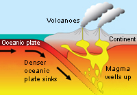
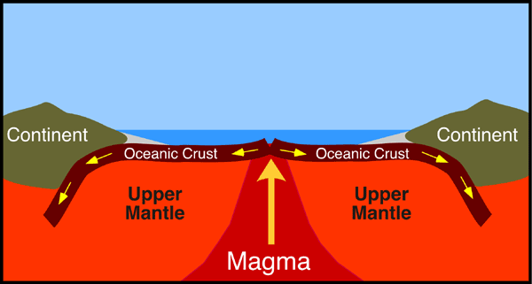
The oceanic crusts contain evidence of plate movement because near spreading ridges material rises due to convection creating new oceanic crust and pushing the existing crust aside (figure 4). 
Magnetic striping is identifying the alignment of iron molecules with the magnetic field. The ocean floor records Earth’s magnetic history. In the past the direction of the molecules flip indicating that the Earth’s magnetic field has flipped since its origin (figure 5).
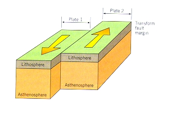
There are three types of plate boundaries. Transform boundaries, convergent boundaries, and divergent boundaries. Transform boundaries are created when two plates move along each other in opposite directions (figure 6).
A convergent boundary is where two plates are moving away towards each other. If the two plates are oceanic or one continental and one oceanic then one oceanic plate will sink below the other plate.If the two plates are continental then they create mountains as both have equal density.These boundaries can cause mountains to form such as the Himalayas (figure 7).
A divergent plate boundary is where two plates are moving away from each other (figure 8).
The devastating tsunami that wiped out many lives in Japan was caused by the largest fault slip recorded. The magnitude 9 earthquake occurred along the Japan trench. Unlike other high magnitude earthquakes, which usually slip around 20-25 meters, but the 2011 quake slipped about 50 meters. This movement was enough to force up water and cause a devastating tsunami.
The friction of rock-on-rock movement would not have allowed such a large slip, so a lubricator such as clay must have been present. Clay is an incredibly slippery substance, so it encourages large slips at plate boundaries. The clay coating on the plate helped reduce the heat and friction produced by the sudden slip. The severity of the earthquake, and therefore the tsunami, are at fault of the clay. (Lee 2013)
Figure 8-http://serc.carleton.edu/images/eet/seismicwave/spreading_center.gif
No comments:
Post a Comment